(English follows)
Mémoire soumis à la MRC Memphrémagog durant la période de consultation publique au sujet du « Plan de gestion de la zone inondable de North Hatley »
Bonsoir
Je vous remercie Monsieur le Préfet, ainsi que les maires et mairesses du comité d’aménagement pour me laisser le temps pour faire ces commentaires.
Pour ceux ou celles qui ne me connaissent pas, je suis Michael Grayson, citoyen de North Hatley depuis 15 ans, et aussi ingénieur-environnementaliste.
Je vous promets de garder ma présentation la moins technique possible.
Je commencerai en vous montrant les extraits de deux cartes qui traitent du même sujet … les zones d’inondation à North Hatley … mais avec des résultats très différents.
- L’une était mandatée par la municipalité fin 2012 et livrée début 2013 par les arpenteurs-géomètres Ouellet, Couture (Ecce Terra).
Voir Carte #1 à l’Annexe 1.
À la demande de la municipalité, ils ont tracé sur le fond topographique les contours correspondant aux niveaux du lac Massawippi lors des crues de 20 et 100 ans de récurrence.
Ces données (162.16 et 162.56) proviennent du Ministère de l’Environnement.
(Dans cet exposé, j’utiliserai cette abréviation)
- L’autre carte était livrée à la municipalité quelques mois plus tard, par les services EXP. C’est la carte adoptée en 2015 qui est en vigueur dans le schéma d’aménagement de la MRC : la Carte A2-7a.
Voir Carte #2 à l’Annexe 1.
Cette carte montre l’étendue des inondations pour des périodes de retour de 20 et 100 ans, résultant d’une simulation du comportement de la rivière Massawippi.
Les aires en rouge représentent l’étendue des eaux lors d’une inondation de période de retour de 20 ans (zone de grand courant). Lors d’un événement de 100 ans, les eaux couvrent les aires en jaune en plus.
En comparant les deux cartes, vous voyez clairement que les inondations touchent beaucoup plus de terrain, selon la première carte.
Comment expliquer ces grandes différences ? Deux facteurs sont les causes principales.
- Le premier résulte de deux différentes façons d’interpréter la provenance des eaux qui envahissent cette zone périodiquement.
- Selon la simulation d’EXP réalisée en 2013, les niveaux d’eau dans la zone inondable sont directement liés aux niveaux calculés sur la rivière, pour toutes les périodes de retour.
C’est paradoxal qu’en même temps EXP affirme dans son étude que « Le terrain en bordure de la rivière est plus élevé que les terrains à aménager, ce qui empêcherait théoriquement l’eau de la rivière de les inonder ».
- De son côté, la carte topographique montre la situation quand les eaux du lac débordent et couvrent cette zone.
L’effet d’étranglement, où la rivière passe sous le pont et par la suite entre le Pilsen d’un bord et le mur de pierres de l’autre, force les eaux du lac à monter et à déborder occasionnellement face au Parc Dreamland.
Je reviendrai à ce sujet tantôt.
- L’autre facteur qui explique cette grande différence est la mauvaise interprétation faite en 2013 du pont routier à l’embouchure de la rivière.
En répondant à mon allégation de cette erreur en janvier 2015, EXP a continué d’affirmer que le dessous du pont était 63 cm plus bas qu’en réalité.
Donc l’effet d’étranglement a été amplifié dans leur analyse par cette fausse interprétation du pont. Le Ministère de l’Environnement a tout récemment reconnu la nécessité de revoir l’analyse à la lumière de cette erreur.
Il est intéressant de noter à quel point la première carte corresponde à la carte des zones inondables de North Hatley qui était en vigueur jusqu’à ce qu’elle soit remplacée en 2015 par la carte révisée.
Nous voyons alors que deux différents systèmes peuvent causer des inondations dans la zone à l’étude :
- la rivière lors d’épisodes plus fréquents et moins sévères
- le lac durant des grandes crues quand la rivière ne répond plus à la demande
- Jusqu’au moment où le niveau du lac atteint l’élévation de la rue Main à son point le plus bas (à sa jonction avec ch. Capelton), la rivière est la principale cause d’inondation dans la zone.
Le ruisseau Kezar contribue un peu aussi.
- Mais, quand le niveau du lac dépasse le niveau de la route, les eaux commencent à envahir le site directement sans passer par la rivière.
Le lac devient alors le facteur contrôlant les niveaux d’eau dans la zone.
Cette situation arrive à une période de retour d’environ 25 ans selon les données du Ministère de l’Environnement.
- Le dernier épisode d’inondation provenant directement du lac était en 1994.
Le niveau du lac était 162.40 m, tel que le confirme EXP, et l’eau frôlait le dessous du pont. Voir la Figure 1 à l’Annexe 2.
À ce moment, l’eau traversant la rue Main avait une profondeur de 15-20 cm.
Voir la Figure 2.
- Lors d’un évènement de 100 ans, l’eau traversant la route aurait une profondeur de 30 – 35 cm
- Des photos du passé montrent l’eau turbulente traversant la route et s’acheminant vers la zone à l’étude en suivant le topo et le chemin de la moindre résistance. L’analyse de ces photos nous permet d’estimer une vitesse d’écoulement d’au moins 10 kmh.
- En 2014, la municipalité a posé des sacs de sable en bordure de la rue Main pour prévenir un débordement.
Il serait tout à fait irréaliste de penser qu’un tel acte pourrait contrôler les eaux lors d’une plus grande crue.
- Dû aux effets des changements climatiques, l’eau pourrait atteindre le niveau de la route plus fréquemment, possiblement aux 20 ans et non pas 25.
Je dois souligner que la première carte correspond très bien à la réalité observée sur le terrain.
- Des résidents du côté est du ch. Capelton attestent de la justesse des contours tracés par Ecce Terra.
- Des photos prises lors des inondations de 1994 montrent les pompes à essence derrière le dépanneur entourées de 30-40 cm d’eau : une autre confirmation de la validité de cette carte.
Voir la Figure 3.
Par contre, la carte « officielle » montre cette aire comme étant exempte d’eau, même lors d’un événement de récurrence 100 ans.
Selon la carte des arpenteurs, les eaux atteindront des profondeurs de 80-90 cm autour des blocs M1 et M2 lors d’événements de 20 à 25 ans de récurrence, et jusqu’à 125 cm aux 100 ans.
Voir la Carte #3 pour l’emplacement des blocs d’habitation.
Ces profondeurs sont de 50 à 60 cm plus importantes que celles indiquées dans l’étude servant à produire la carte de la MRC. Cette différence corresponde parfaitement à l’erreur faite en mesurant le dégagement vertical du pont.
Le Tableau 3 à la page 25 du Plan de gestion perd sa validité. Il indique que 46% du secteur M1 et 39% du secteur M2 se trouvent en zone de grand courant. Par contre, lorsque le lac déborde sur le site, M1 est entièrement dans la zone 0-20 ans, et M2 presque entièrement.
Quant au secteur C1 où une utilisation mixte (commerciale / résidentielle) est proposée, au moins la moitié est située en zone de grand courant et l’autre moitié en zone de faible courant. L’eau atteindrait des profondeurs de 40-50 cm aux 20 ans et près d’un mètre aux 100 ans.
(Pourtant la MRC atteste que cette zone est hors des zones d’inondation).
Rôle de la zone à l’étude
Je voudrais tourner rapidement au rôle important que cette zone doit jouer occasionnellement comme voie de débordement du lac, et ce depuis plusieurs décennies. Autrefois une plaine plus large, allant du chemin Capelton jusqu’à la rivière s’inondait entièrement, comme montre la Figure 4. Le remblayage progressif du terrain à l’est de la voie ferrée a forcé les eaux à suivre le chemin le plus bas qui passait du sud vers le nord à travers la zone à l’étude.
La partie la plus creuse de ce terrain ne devrait pas être obstruée. Elle devrait reprendre pleinement le rôle de voie de débordement du lac, comme il le jouait jusqu’en 2002. À ce moment, la municipalité a construit, sans l’autorisation requise du Ministère de l’Environnement, une bretelle du stationnement municipal qui bloquait effectivement cette voie d’évacuation. Il n’a pas eu une grande crue depuis 1994 … la prochaine arrivera bientôt en toute probabilité.
Le réaménagement du ruisseau Kezar tel qu’exigé par le Ministère nécessitera de pratiquer une percée plus importante dans ce « barrage », permettant ainsi l’écoulement libre des eaux à travers le site lors des grandes crues.
Conclusion
Tous ces facteurs me poussent à questionner l’utilité de discuter cette version du Plan de gestion aujourd’hui. Elle est incomplète et erronée.
Je dois aussi questionner la vigilance avec laquelle différents ministères ont traité ce dossier.
Même si la carte de la MRC était valide, je resterais étonné qu’on se force autant à justifier la construction de ces bâtiments dans des zones de grand courant. Pourquoi doit-on courir de tels risques, sur des terrains où des permis de construction ont été refusés depuis longtemps?
En apportant les corrections requises à la carte, ces constructions deviennent impensables.
Michael Grayson, ing.
13 avril 2017
ANNEXE 1 : Cartes #1 – 3
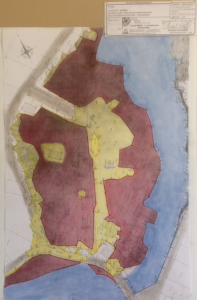
Carte #1 : Extrait du plan topographique, Ecce Terra arpenteurs-géomètres
Produit pour la municipalité de North HatleyFévrier 2013
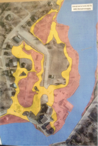
Carte #2 : Extrait de la carte A2-7a, Schéma d’aménagement, MRC Memphrémagog
Produit pour la municipalité de North HatleyJuin 2013
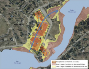
Carte #3 : Emplacement prévu des bâtiments dans la plaine inondable
M1, M2 et R1 abrite un total de 210 unités d’habitation (condos)
M2 : 5 étages M1 et R1 : 4 étages
Ce corridor agit de temps en temps comme voie de débordement du lac, lorsque le niveau du lac dépasse celui de la route (Rue Main). Suite au remblayage progressif fait sur l’est de cette ancienne zone marécageuse, les eaux du lac coulent avec plus de force à travers la zone à l’étude, pendant des périodes de grandes crues. La flèche bleue indique schématiquement le chemin que l’eau doit suivre avant de rejoindre la rivière où elle s’élargit.
ANNEXE 2 : Figures 1 – 4

FIGURE #1 : L’eau touchant le dessous du pont le 18 avril 1994.
On a fermé le pont par mesure de prudence.

FIGURE #2 : Intersection du chemin Capelton et la rue Main, 17 avril 1994.
L’eau coule par-dessus la route pour ensuite suivre son chemin à travers la zone à l’étude.
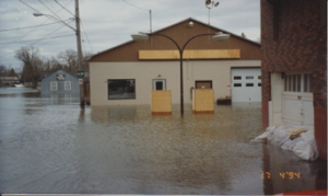
FIGURE #3 : Les pompes à essence derrière le dépanneur, 17 avril 1994
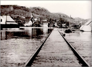
FIGURE #4 : Épisode d’inondation durant les années 1930.
Vue vers le nord avec le site de développement situé du côté gauche de la voie ferrée.
Le remblayage du secteur à droite (maintenant le Parc Riverside) pousse les eaux à couler à travers la zone à l’étude, avec plus de force, lors d’événements de grande crue tels qu’en 1994.
Les opinions exprimées sur ce site Web reflètent celles de leurs auteurs. L’espace est offert à titre de service à la communauté et FANHCA, ses administrateurs et son hébergeur ne peuvent en aucun cas être tenus responsables des opinions qui y sont émises.


